Satellite and aerial images of the Earth's surface are becoming more widely available. One particulary rich source on the World Wide Web is TerraServer, from which these U. S. Geological Survey images were taken. With these images, it is possible to trace older alignments of Route 66, to reconcile early descriptions of the various alignments with more modern road maps, or to view alignments on which you cannot drive. Shown below are some examples.
UPDATES:
| October 1, 1999 | Additional ground-based photos near Chain of Rocks, IL, and Bellemont, AZ are added. | |
| January 26, 1999 | Further information from Teri Cleeland about the alignments in Arizona are incorporated. | |
| December 8, 1998 | Further information from Jim Ross, Jerry McClanahan, and Teri Cleeland has been incorporated. | |
| November 25, 1998 | Many thanks to Route 66 author and expert Jim Ross for valuable information to accompany these images. | |
| November 5, 1998 | The first version of satimg.htm for polite company is brought on line. |
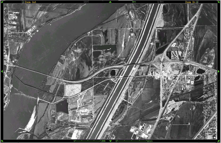
On the left is the Chain of Rocks bridge over the Mississippi River, east of St. Louis, MO. At the center of the image is a dark, almost circular pond, separating I-270 on the north (above) and two Route 66 alignments immediately below. East from that point is a bridge carrying the newer alignment over the canal, then to the intersection with Illinois route 3. West from that point (below the pond) Route 66 roughly matches I-270 just to the north. A bit less than 2 km (use the scale at the bottom of the image) from the pond is an intersection. The bright dirt road south, then east takes you to the sandy bank of the river where you can see the bridge. Back at the intersection, the darker road straight ahead takes you to the bridge approach.
Jim Ross adds: If you veer off Chain of Rocks Road westbound just before the canal bridge, you will find below that bridge a strip of old 66 concrete. The extension of this first paved alignment is seen in the aerial photo as the horizontal road extending west from the area of the pond. (Here is a photo looking east, with the canal bridge on the right and the twin bridges of I-270 on the left). About a half mile later, it intersects another road just before the embankment of I-270. From that junction, if you are on-site, you can see the old road butting heads with the interstate. From that point, original 66 followed the superslab briefly, then angled back southwesterly in a sweeping curve (this part is totally obliterated) to approach the bridge. A few traces of this road can be found in the overflow area on the north side of Chain of Rocks Road just east of the main bridge. Back to IL, or 66:51
Now here is a curiosity, two in fact. The section of road extending from the top right to the lower middle is Route 66 in Kansas, about 0.5 mile north of the state line with Oklahoma. You can see a southbound truck negotiating the middle of the two curves. That truck is about to cross a road that Street Atlas V5 calls old Route 66! Jim Ross tells us that the old alignment was the right angle behind the Wal-Mart (later a curved section was added) and the truck is on the newest alignment forming the hypoteneuse in front of the store.
The second curiosity is what appears to be an old drive-in theatre at the bottom center of the image. Back to KS, or 66:51
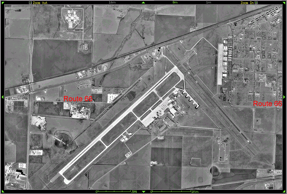
Here is the visual answer to the question "What happens if you drop an airport on top of Route 66?". East of Amarillo, TX, is the airport, nestled between I-40 to the south and I-40 Business to the north. East of the airport, at exit #85 where the two interstates divide, you could instead take Ranch 2575 west towards the airport. After becoming 1st Street, a gate stops you, but you can see the pavement continuing west, ending just before encountering the runway. If you look closely, you can see the remaining scar, a bit darker than its surroundings, as it crosses the airport. Pavement returns at the left side of the image, where the road is known as Triangle Drive. Back to TX, or 66:51
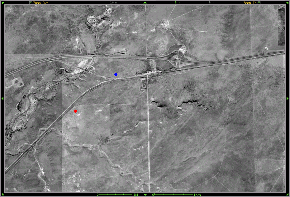
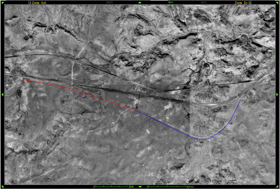
Oddly, the political boundary separating Texas from New Mexico coincides with the light nearly vertical road near the center of this image.(!) I-40 interchange #0 in Texas is just east of the line. Below it is Route 66, extending into the town of Glenrio, part of which is in Texas and the remainder in New Mexico. West out of Glenrio, a 1930s alignment turns more south, and continues to Endee. A later alignment from the 1950s can be seen turning a bit north (at the blue dot), over a bridge above the wash, passing under I-40, then angling a little south to parallel the interstate westbound. It appears to be possible to get to this alignment by exiting I-40 at interchange #372. Jim Ross points out that an even earlier alignment from the 1920s left Glerio southbound, then turned west after about 0.4 mile to approach and continue on the south side of the RR tracks (at the red dot), paralleling the 1930s alignment. Back to NM, or 66:51
In the center of this image is I-40 interchange #321, west of Tucumcari, NM, where a nut-roll at Stuckey's awaits you. Immediately south is Route 66. Taking a right turn you can continue on Route 66 (marked underneath in red) westbound. However, Route 66 eastbound (in blue) rests on private land and is fenced off. Back to NM, or 66:51

Even though this is a big gif, you may want to import this to an image program so that you can enlarge portions of it. This is an interesting region between Bellemont and Parks, AZ, where Route 66 has many alignments.
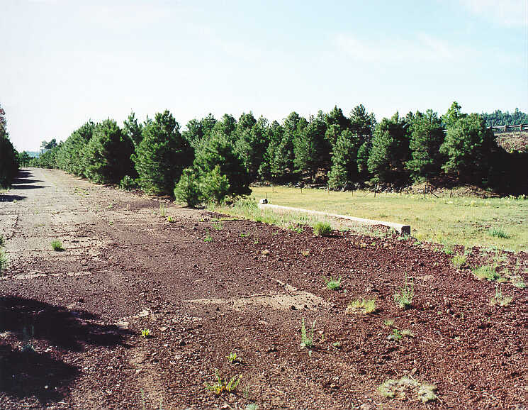
At the lower right is Bellemont. It can be reached by taking I-40 interchange #185. South of that interchange is the 1941 alignment, indicated by the red dot below it. It connects with the joined 1931 and 1921 alignments, indicated by the blue dot below it. These three alignments split. The 1941 alignment continues west for about a mile, and is terminated by the interstate. At the split, you can see the faint remnants of the 1921 alignment (blue dot) and the 1931 alignment (yellow dot) as they diverge while crossing the interstate and heading up Fortynine Hill. Here is a photo, taken from the 1921-1931 vertex, showing them crossing the 1941 alignment and then continuing through the trees.
Back at the interchange, if you take the frontage road on the northside of the interstate, it leads you west, first to the 1921 alignment, then to the 1931 alignment. These alignments extend northwest around Fortynine Hill (7864 feet elevation), rejoin near the apex of the curve, then continue southwest down the hill. Teri suspects that the 1921 alignment diverges west from the 1931 alignment, rejoining about a mile farther down the hill. Here is some discussion about that suspect alignment. Trivia: this 1931 loop around Fortnine Hilll carries you to the highest point on Route 66, about 7300 feet.
On the left, near Parks, several alignments of Route 66 converge and branch. Extending down from Fortynine Hill are the 1921 and 1931 alignments, which separate at the blue dot. The 1931 alignment (yellow dot) extends for about a mile, then rejoins the others. The 0.5 mile 1921 alignment (second blue dot) is just barely visible. The photograph back on the AZ.HTM page shows it as a grassy cut through the trees. It approaches the 1941 alignment (red dot), and then extends northwestward to cross with the 1931 alignment near Parks AZ. The 1941 alignment eastbound is terminated by the interstate at the other red dot. Here is a photo of that section, looking southwest towards the Interstate. There is an Interstate sign on the extreme left, and the guard rail on the extreme right of the photo. Between Bellemont and Parks, several short segments of the 1941 alignment (red lines) can be glimpsed just south of the interstate. Back to AZ, or 66:51
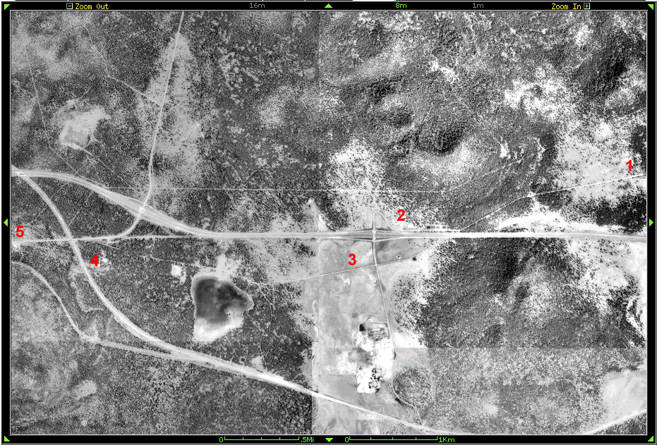
Shown here is an aerial photograph, approximately centered at I-40 interchange #167 about 4 miles east of Williams, AZ. You would be travelling on Deer Farm Road westbound, having left I-40 at interchange #171 to visit with the many creatures at the Deer Farm. You are on the 1921 alignment of Route 66, a dirt road, indicated in the image by the red number 1. As you approach I-40, the road angles to the right and pavement begins. You can stop here and look across the interstate and see where Route 66 continues. You can get there by curving up to the interchange, indicated by the number 2. After crossing the interstate, Route 66 continues at the intersection as Forest Road 51A at 3, the approximate location of the photograph back on the AZ.HTM page. The section eastbound at that intersection is on private land. About 1.6 miles west of the intersection, you can turn to the right to rejoin the 1932 alignment, at whose junction you can see the ghost of the pre-interstate connection to highway 64 (looks like an upside-down "Y"). If you have a high-clearance vehicle, continue straight ahead on the 1921 alignment. The road (twin wheel ruts actually) continues on to the number 4 indicator, curving around the top of the digit as I have placed it. It terminates at the embankment for the railroad. Notice that you can get to the section west of the railway by going east southeast from point 5. Back to AZ, or 66:51
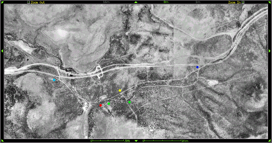
On the west side of Williams, south of the interstate, are more of the older Route 66 alignments. Just west of center of this image is I-40 interchange #157. South from that interchange is an intersection with Route 66, denoted by the red dot. You can go west from that interchange for about 0.8 mile until you encounter the interstate at the light blue dot.
Back at the intersection (red dot), go east. After about 0.1 mile, at the first green dot, you can see the 1921 alignment angling off to the right towards the second green dot. This section is for bicycles only. At the yellow dot, the 1931 alignment straight ahead continues to the dark blue dot, where it rejoins the 1921 alignment as both encounter the interstate. The 1931 alignment is for bicycles only. A right at the yellow dot and a left at the green dot brings you to the 1921 alignment. It is possible to drive partway east on this alignment. Back to AZ, or 66:51
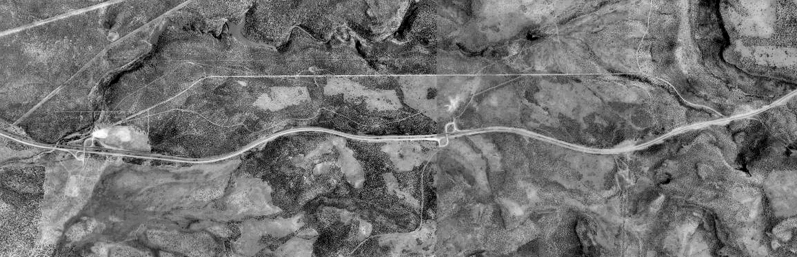
Between Williams, AZ, and Ash Fork are some old alignments of Route 66. In this image, you can see I-40, and above it to the north, old Route 66. The figure-8 interchange near the center is #151. Taking this interchange, and heading north, then east northeast (along a short section of the 1921 alignment) takes you to the 1931 alignment. It extends for about 2 miles east, then south-east, ending at the top of a hill up against I-40. If you backtrack and head west, you can return to interchange #151, or continue down the hill due west along the 1931 alignment and then west south-west to interchange #149. Between the 1931 alignment and I-40 is the sinuous 1921 alignment. Teri tells us that the starlike whitish feature seen just above the interchange #151 loop, obliterating part of the 1921 alignment, is the visual answer to the question "What happens if you drop an I-40 concrete processing plant on top of Route 66?". Back to AZ, or 66:51